

Download Products |
|
|
At a minimum using the FARSITE fire behavior model to simulate fires in chaparral will require spatial data that is organized into five themes.
For fires in forested areas additional spatial data describing tree crown characteristics will be required and is not mentioned here. All five basic static input layers used in the Santa Monica Mountains prototype are available for download at this site. Be aware that in addition to these static datasets, FARSITE can also accept spatial data describing the meteorological conditions during a fire, such as the wind speed, direction, air temperature, and relative humidity. Because these datasets vary based upon the idiosyncratic conditions you are trying to simulate, we do not provide them for download.
All of the spatial data that can be downloaded from this page is a simple space delimited ASCII text file suitable for import into FARSITE (as well as ArcView) that has been compressed with WinZip. The text file itself consists of two parts:
(1) a brief header with the following information (the values shown here are the actual header values specific to the Santa Monica Mountains):
| ncols | 8700 |
| nrows | 3000 |
| xllcorner | 298032 |
| yllcorner | 3761874 |
| cellsize | 10 |
| NODATA_value | -9999 |
(2) the raw data of space delimited values.
| -9999 -9999 -9999 etc... |
In order to merge each of the five themes into a single landscape file used by FARSITE, the information in all five headers will have to be identical. This means that the cell sizes and corner points of your input datasets will have to be identical. Naturally the spatial attribute data may vary on a cell-by-cell basis.
The projection information for each
of the datasets is the same. You will need this if you wish to import the ASCII grids into
your own GIS software package for viewing with datasets in other (potentially)
different coordinate systems.
projection
UTM
zone
11
map units
meters
datum
NAD27
spheroid
Clarke 1866
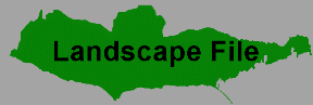
The five compressed ASCII files available here can be used to generate a FARSITE landscape file using a utility available from within the FARSITE application. The landscape file, with an extension of ".lcp", is the fundamental unit of organization for managing the spatial data used by the FARSITE model. As a courtesy, we have also provided WinZip compressed landscape files for download in case you want to skip over the generation of the landscape file. These landscape files may not work with versions of FARSITE older than 3.0.
Although the FARSITE documentation provides a wealth of information about the model development and application, some of the areas in which each dataset is used in the model are mentioned next to each of the download icons below.
Download Products By Clicking on Map Image!
I have expanded the download page to include data from other areas. Visit the Santa Monica Mountains
download page.
Elevation: Derived from a 10 meter Digital Elevation Model (DEM). Influences the adiabatic lapse rates for temperature (1 deg Celsius / 100 m elevation gain) and humidity (0.2 % per 100 m elevation gain).
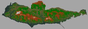
Elevation Data
Slope: Derived from a 10 meter Digital Elevation Model(DEM). Influences the orientation and eccentricity of the predicted fire perimeters. Also used to calculate the diurnal fluctuation in dead fuel moisture.
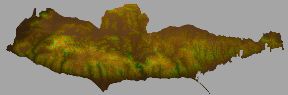
Slope Data
Aspect: Derived from a 10 meter Digital Elevation Model(DEM). Used to calculate the diurnal fluctuation in dead fuel moisture.
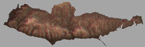
Aspect Data
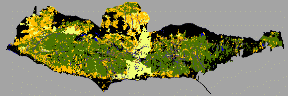
Fuels: To find out more about how this dataset was generated go here. Fuel attributes that influence the predicted rate of spread include the fuel bed bulk density, surface-area-to-volume ratio, and moisture content. More information abut what these attributes mean is available here.
The 1999 Custom Fuels dataset represents the most up-to-date snapshot of the fuels condition in the Santa Monica Mountains available today.
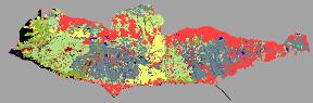
1999 Custom Fuels Data
You will also need to download a textfile that contains the custom fuel model attributes. Get it here. This textfile is suitable for input into FARSITE. The file is organized into a space delimeted sequence of attributes in the following order:
Fuel Model Num
Dead 1 Hour Fuel Load
Dead 10 Hour Fuel Load
Dead 100 Hour Fuel Load
Live Herb Fuel Load
Live Woody Fuel Load
Dead 1 Hour SAV
Live Herb SAV
Live Woody SAV
Fuel Bed Depth
Moisture of Extinction
Dead Fuels Heat Content
Live Fuels Heat Content
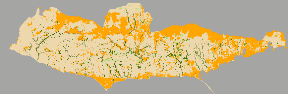
In addition to the Custom Fuels Data, a traditional NFFL Fuels Dataset meant to reflect conditions in 1999 is also available for download. The NFFL Fuels Data only uses fuel models that are one of the thirteen standard National Forest Fire Laboratory (NFFL) Fuel Models. More information about these models is available here. An interesting comparison between NFFL Fuel Model 4, the traditional fuel model used in chaparral fuels, and the custom chaparral fuel models is available here.
1999 NFFL Fuels Data
Canopy Cover: Greater canopy coverage reduces the windspeed experienced at ground level and inhibits the ability of the sun and wind to prematurely dry dead fuels.
Canopy Cover Data
FARSITE Landscape (LCP) Files: The fundamental unit of organization for managing the spatial data used by the FARSITE model.
1999 FARSITE LCP File (Custom Fuels)
1999 FARSITE LCP File (NFFL Fuels)
|
|