


Fuels Mapping |
|
|
|
How can fuels be mapped?
Although describing the surface-area-to-volume, heat content, and moisture of extinction as a fixed property of a species is reasonable, describing the biomass and stand height in this way is not. Biomass accumulation in chaparral, even among stands of identical species composition, varies based upon a suite of environmental conditions: stand disturbance history, site quality, and floristic composition (Specht, 1969; Riggan, et. al., 1988). Two alternative techniques can be used for characterizing the spatial variability in aboveground fuel biomass. The first approach uses empirical data to correlate the stand environmental conditions to the species allometry. However, robust statistical relationships cannot be obtained from this technique without a sufficiently large and diverse set of ground-based samples. Alternatively, heuristic or rule-based approaches to describing fuel biomass accumulation can be used to attempt to recreate some of the spatial variability present in the landscape. Although the lack of empiricism in the technique is troublesome, this approach may be suitable when little ground-based data exists for an allometric approach. The technique used here applies a non-statistical heuristic model of postfire fuels regeneration to map chaparral fuels in the Santa Monica Mountains.
How were fuels mapped in the Santa Monica Mountains?
Although
there was a lack of ground-based fuels data available for the Santa Monica Mountains,
there exists an abundance of ancillary GIS basedata which could serve as a surrogate for
measuring the variables thought to be important in assessing fuels development. The first
step in developing a spatial fuels dataset was to identify a study area to constrain the
analysis. Rather than using an arbitrary political boundary, the Santa Monica Mountains
Ecological Zone was used as a mask beyond which data was not evaluated. The outermost
boundary of the ecological zone mask area is defined by the many watersheds which completely
contain the Santa Monica Mountains and the portion of the the Simi Hills below the 118 freeway.
The mask also approximates the maximum extent of urban encroachment into the foothill areas surrounding
the mountains. For a better appreciation of the configuration of the natural areas relative to the
outlying urban and suburban centers go here (this may take
a while to load, the image is approximately 97kb).
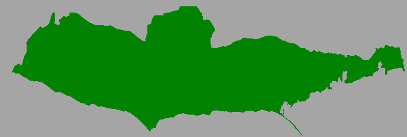
Santa Monica Mountains Mask

Since the fuel condition
in any particular area is in a state of constant flux, an important constraint for the heuristic chosen
to map fuels is that it is sensitive to the postfire successional changes observed in chaparral stands.
In order to satisfy this constraint, a static postfire successional sequence was assumed. With this
assumption, the age-sensitive fuel condition for any area could be determined by evaluating three
questions:
Last Updated: Marco Morais