

Ultimate Fuels Condition |
|
|
What is the ultimate fuel condition throughout the Santa Monica Mountains?
The ultimate fuel condition was determined through the synthesis of three pieces of information. The first was a vegetation cover map produced for the National Park Service and described in Franklin, 1997. It is important to emphasize that this map describes the floristic composition of a particular area where the full floristic potential is achieved. In other words, areas which had been recently burned at the time the image was acquired in the spring of 1993 were mapped to their potential vegetation cover type rather than whatever immediate postfire composition they displayed.
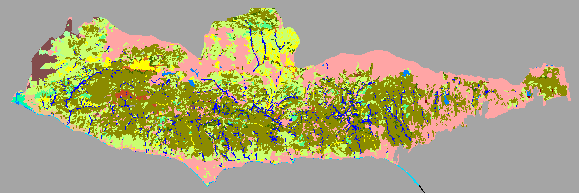
Santa Monica Mountains Cover Types |
|
The second piece of information used to map ultimate fuel condition was a map of riparian areas produced by the National Park Service and described in National Park Service, 1997. Although riparian areas are generally long linear features without a large spatial extent, they are important because the fire behavior through these is areas is generally far more subdued in comparison to grass and shrub fuels. Unlike stands of chaparral where the fire is carried through the crowns of the shrubs, the fuels responsible for carrying fire through riparian areas exists along the ground in the accumulated leaf litter. An existing standard national fuel model, NFFL 9 was used to describe fuels in these areas.
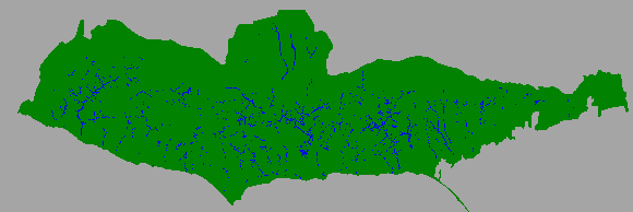
Santa Monica Mountains Riparian Areas |
|
The third piece of information used to map ultimate fuel condition was a map of the landuse for the area based upon a 1990 SCAG (Southern California Association of Governments) spatial dataset. As a result of the increased urbanization in the foothills surrounding the north, west, and east sides of the Santa Monicas, many vegetation communities have been disturbed or removed to the point that they will never return to their original state. The distribution of these disturbed areas is approximated by the extent of non-rural developed areas. Consequently, the SCAG data was used to associate areas of urban development with an appropriate fuel model, either grass or wildland urban interface. These areas have been incorporated into the image of Santa Monica Mountain cover types shown above as part of the category labeled 'development'.
| Next: Fuels Development Sequence |
|
|