|
Databases of past fire occurrence are increasingly available for large parks and forests. The types of analysis possible will depend several factors:
|
•
|
the length of the period of record, |
|
•
|
the spatial extent of coverage, |
|
•
|
how fires are recorded (e.g., mapped perimeters & ignition points), |
|
•
|
accuracy (e.g., spatial, temporal, & size thresholds applied), |
|
•
|
availability of additional data (e.g., vegetation and/or topography). |
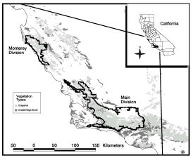
Much of my work to date has been on the detailed fire history of Los Padres National Forest, which is located along central coastal California.
|
Los Padres National Forest (LPNF hereafter) consists of two components, the northern Monterey Division and the southern Main Division. The region experiences a Mediterranean-type climate (i.e., cool/wet winters and warm/dry summers), and vegetation is primarily chaparral-dominated shrublands. Thankfully, a mapped fire history was compiled and maintained over the years by Fritz Cahill of the U.S. Forest Service. |
|
|
|
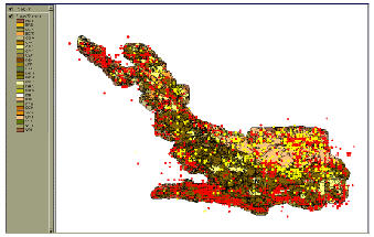
The fire history of LPNF extends from 1911-present and has 2 forms of spatial data, ignition points (e.g., Main Division, right) and fire perimeters (e.g., below). The ignition point database records date and cause, and fires of all sizes should have an entry in this database. Lightning ignitions are shown here in yellow, occurring primarily at higher elevations. Other causes are shown in red, the vast majority of which are started by humans, and often follow the road network. |
|
|
|
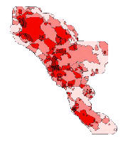
The perimeters of all fires larger than ~300 acres, if they burned within or near LPNF boundaries (i.e., within 3200m), were mapped over the period of record. As with the point data, these fire perimeters were eventually entered into a GIS for analysis. From these data, one can investigate relationships between environmental variables and the fire regime or quantify how much of the landscape has burned at different ages and frequencies. Fire patterns for the Monterey Division are shown here, with darker areas indicating those that burn more frequently. |
The Extremal Fire Regime: For ecosystems that are dominated by infrequent, very large fires, one can employ the statistics of extremes to characterize the likelihood of unusual events. This is the same statistical approach used to estimate return intervals for floods (e.g., predicting the size of the "100-year" event). This type of information can be useful to fire managers for estimating how often fires of different sizes may be expected in a given area, how large an area might be needed to accommodate fires of a given return interval, or whether probabilities have changed over time. I have used this method to examine the "extremal fire regime" of LPNF in an Ecological Applications paper.
Age Dependence and Large Fire Occurrence: A contested issue in fire research and management is often how modern human activities, especially recent fire suppression, have affected fire-prone ecosystems. In many ecosystems that prehistorically experienced frequent surface fires, fire suppression has altered stand structure, resulting in the accumulation of fuels that can act as a "ladder" for fire to propagate into tree canopies. Large and intense "crown fires" in these ecosystems are therefore seen as relatively recent phenomena caused by human alterations to the natural fire regime.
In many of California’s chaparral-dominated shrubland ecosystems, there are several reasons why one might argue that large crown fires are probably natural (if infrequent) events. For one thing, shrubland fires are typically stand-replacing and of relatively high intensity. In addition, periods of extreme fire weather, such as the hot and dry Santa Ana winds of southern and central California, can drive fire through many age classes and vegetation types that might not otherwise readily burn. What is missing in the debate over large shrubland fires is a quantitative analysis of the relative importance of vegetation age versus extreme fire weather in controlling fire spread. Here is a link to an abstract for a presentation I gave on this topic, and a paper
describing this work is soon to be out in the journal Ecology. The basic approach is to quantify historical age-at-burn distributions with a generalized Weibull function and to characterize how the hazard of burning changes with time since the last fire. Follow this link to a list of references for fire frequency analysis in a variety of fire-prone ecosystems.|
[Fire History] |
||
|
Last updated: <February, 2003>
|


